13 KiB
13 KiB
| title | date | author | tags | categories | ||||
|---|---|---|---|---|---|---|---|---|
| 在线编辑 | 2020-11-2 | ac |
|
|
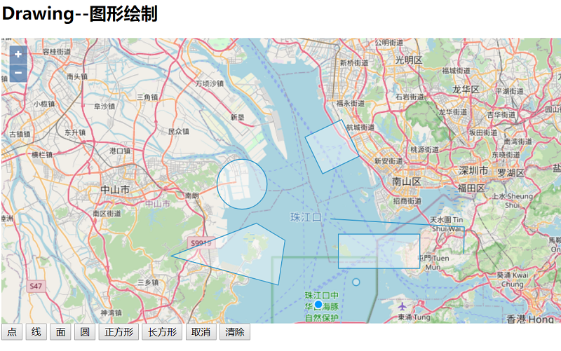
1 Draw 对象
ol在客户端(浏览器)可以通过Draw交互对象在map中绘制几何图形。
初始化Draw对象时,在构造参数options中指定type参数和用于存储所绘制图形的数据源source即可,但type类型必须是'Point', 'LineString', 'LinearRing', 'Polygon', 'MultiPoint', 'MultiLineString', 'MultiPolygon', 'GeometryCollection', 'Circle'中的类型。
当然在Draw中也提供了一些方法用于绘制自定义图形。
new Draw(options),options常用的构造参数
| name | type | Description |
|---|---|---|
| type | module:ol/geom/GeometryType | 指定要绘制的几何类型 |
| clickTolerance | number | 绘制时鼠标点击的容差 |
| features | ol/Collection~Collection<ol/Feature> | 用于存储绘制图形的要素集合 |
| source | ol/source/Vector~VectorSource | 用于存储绘制图形的数据源 |
| dragVertexDelay | number (defaults to 500) | 当前顶点被拖动到其确切位置之前的延迟(毫秒)。 |
| snapTolerance | number(defaults to 12) | 可拖放对象离目标对象的距离低于此像素值时开始靠拢 |
| stopClick | boolean(defaults to false) | 停止在绘图期间触发的单击、singleclick和doubleclick事件。 |
| finishCondition | ol/events/condition~Condition | 绘制结束的条件函数 |
| style | ol/style/Style~StyleLike | 绘制图形使用的渲染样式 |
| geometryFunction | ol/interaction/Draw~GeometryFunction | 当绘制图形的坐标发生变化时,调用的函数。它接受一个坐标数组、一个可选的现有几何图形和一个投影作为参数,并返回一个几何图形。 |
| freehand | boolean(defaults to false) | 自由模式,自定义绘制图形 |
| maxPoints | number | 绘制多边形或线的最多点数个数 |
| minPoints | number | 绘制多边形或线的最少点数个数,线默认为2,多边形默认为3 |
与Draw绘制对象对应的有一个ol/interaction/Draw~DrawEvent事件类来处理绘制交互过程中的事件,如:
drawstart:开始绘制要素时触发drawend:绘制结束后触发
示例:
<!doctype html>
<html>
  <head>
    <link rel="stylesheet" href="css/ol.css" type="text/css">
    <style>
      .map {
        height: 400px;
        width: 100%;
      }
    </style>
    <script src="lib/ol.js"></script>
    <title>图形绘制</title>
    <meta charset="UTF-8">
  </head>
  <body>
    <h2>Drawing--图形绘制</h2>
    <div id="map" class="map"></div>
    <div>
      <button onclick="addDrawInteraction('Point')">点</button>
      <button onclick="addDrawInteraction('LineString')">线</button>
      <button onclick="addDrawInteraction('Polygon')">面</button>
      <button onclick="addDrawInteraction('Circle')">圆</button>
      <button onclick="addDrawInteraction('Square')">正方形</button>
      <button onclick="addDrawInteraction('Box')">长方形</button>
      <button onclick="addDrawInteraction('None')">取消</button>
      <button onclick="addDrawInteraction('Clear')">清除</button>
    </div>
    <script type="text/javascript">

      var shenzhen = [113.958334,22.535640];
      var map = new ol.Map({
        target: 'map',
        layers: [
            //作为底图
            new ol.layer.Tile({
                source: new ol.source.OSM()
            })
        ],
        view: new ol.View({
          center: ol.proj.fromLonLat(shenzhen),
          zoom: 10
        })
      });

      //创建矢量数据源,用于存储在线绘制几何对象
      var opterationSource = new ol.source.Vector();
      var vecLayer = new ol.layer.Vector({
          source: opterationSource
      });
      map.addLayer(vecLayer);

      //创建Draw实例
      var draw = null;
      function addDrawInteraction(drawType) {
          //移除原来的draw
          map.removeInteraction(draw);
          draw = null;

          switch (drawType){
              case 'Point':
              case 'LineString':
              case 'Polygon':
              case 'Circle':
                  draw = new ol.interaction.Draw({
                      source:opterationSource,
                      type:drawType,
                      // freehand: true //自由模式,自定义绘制 图形
                  });
                  map.addInteraction(draw);
                  break;
              case 'Square':
                  draw = new ol.interaction.Draw({
                      source:opterationSource,
                      type:'Circle',
                      geometryFunction:ol.interaction.Draw.createRegularPolygon(4)
                  });
                  map.addInteraction(draw);
                  break;
              case 'Box':
                  draw = new ol.interaction.Draw({
                      source:opterationSource,
                      type:'LineString',
                      maxPoints:2,//绘制前多边形或线的最大点数
                      //当几何坐标更新时调用
                      geometryFunction:function (coordinates,geometry) {
                          if(!geometry){
                              geometry = new ol.geom.Polygon(null);//多边形
                          }
                          var start = coordinates[0];
                          var end = coordinates[1];
                          geometry.setCoordinates([
                              [
                                  start,
                                  [start[0],end[1]],
                                  end,
                                  [end[0],start[1]],
                                  start
                              ]
                          ]);
                          return geometry;
                      }
                  });
                  map.addInteraction(draw);
                  break;
              case "Clear":
                  //清除数据源中存储的要素
                  opterationSource.clear() ;
                  break;
          }
          if(draw){
              bindDrawEvent();
          }
      }
      function bindDrawEvent(){
          draw.on("drawstart",function(e){
              console.log("drawstart");
          });
          draw.on("drawend",function(e){
              //从事件源中获取所绘制的几何图形
              var geometry = e.feature.getGeometry();
              console.log("drawend");
          });
      }
    </script>
  </body>
</html>
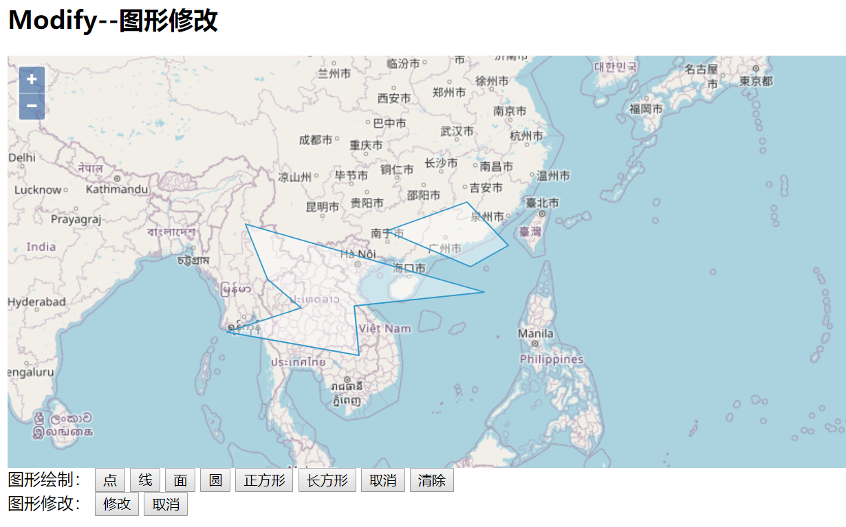
2 Modify对象
如果需要对客户端绘制的图层或要素服务提供的图层进行修改,我们可以使用ol中的modify交互对象完成这类需求。跟Draw对象类似,初始化Modify实例时,需要在构造参数中使用source或features指定数据源或要素集合。将Modify实例添加到map上后就可以修改指定的要素了。通常跟snap交互控件一起使用,方便捕捉几何图形的顶点进行修改。
示例:
<!doctype html>
<html>
  <head>
    <link rel="stylesheet" href="css/ol.css" type="text/css">
    <style>
      .map {
        height: 85vh;
        width: 100%;
      }
    </style>
    <script src="lib/ol.js"></script>
    <script src="lib/jquery-3.1.1.js"></script>
    <title>图形修改</title>
    <meta charset="UTF-8">
  </head>
  <body>
    <h2>Modify--图形修改</h2>
    <div id="map" class="map"></div>
    <div>图形绘制:
      <button onclick="addDrawInteraction('Point')">点</button>
      <button onclick="addDrawInteraction('LineString')">线</button>
      <button onclick="addDrawInteraction('Polygon')">面</button>
      <button onclick="addDrawInteraction('Circle')">圆</button>
      <button onclick="addDrawInteraction('Square')">正方形</button>
      <button onclick="addDrawInteraction('Box')">长方形</button>
      <button onclick="addDrawInteraction('None')">取消</button>
      <button onclick="addDrawInteraction('Clear')">清除</button>
    </div>
    <div>图形修改:
      <button onclick="addModify()">修改</button>
      <button onclick="cancelModify()">取消</button>
    </div>
    <script type="text/javascript">

      var map = new ol.Map({
        target: 'map',
        layers: [
            new ol.layer.Tile({
                source: new ol.source.OSM()
            })
        ],
        view: new ol.View({
          center: ol.proj.fromLonLat([137.41, 23.82]),
          zoom: 4
        })
      });


      //创建矢量数据源,用于存储在线绘制几何对象
      var opterationSource = new ol.source.Vector();
      var vecLayer = new ol.layer.Vector({
          source: opterationSource
      });
      map.addLayer(vecLayer);

      //创建Draw实例
      var draw = null;
      function addDrawInteraction(drawType) {
          //移除原来的draw
          map.removeInteraction(draw);
          draw = null;
          switch (drawType){
              case 'Point':
              case 'LineString':
              case 'Polygon':
              case 'Circle':
                  draw = new ol.interaction.Draw({
                      source:opterationSource,
                      type:drawType,
                  });
                  map.addInteraction(draw);
                  break;
              case 'Square':
                  draw = new ol.interaction.Draw({
                      source:opterationSource,
                      type:'Circle',
                      geometryFunction:ol.interaction.Draw.createRegularPolygon(4)
                  });
                  map.addInteraction(draw);
                  break;
              case 'Box':
                  draw = new ol.interaction.Draw({
                      source:opterationSource,
                      type:'LineString',
                      maxPoints:2,
                      geometryFunction:function (coordinates,geometry) {
                          if(!geometry){
                              geometry = new ol.geom.Polygon(null);//多边形
                          }
                          var start = coordinates[0];
                          var end = coordinates[1];
                          geometry.setCoordinates([
                              [
                                  start,
                                  [start[0],end[1]],
                                  end,
                                  [end[0],start[1]],
                                  start
                              ]
                          ]);
                          return geometry;
                      }
                  });
                  map.addInteraction(draw);
                  break;
              case "Clear":
                  opterationSource.clear() ;
                  break;
          }
      };
      //创建modify实例
      var modify = new ol.interaction.Modify({
          source:opterationSource
      });
      function addModify() {
          map.addInteraction(modify);
      };
      function cancelModify() {
          map.removeInteraction(modify);
      };
    </script>
  </body>
</html>
参考文章
[1] TopoJSON https://www.jianshu.com/p/351fbc010412?from=singlemessage