8.0 KiB
| title | date | author | categries | tags | ||
|---|---|---|---|---|---|---|
| GeoTools-简介 | 2023-11-28 | ac |
|
|
GeoTools-简介
1.简介
GeoTools是一个开源(LGPL) Java代码库,它为地理空间数据的操作提供了符合标准的方法,例如实现地理信息系统。GeoTools库数据结构基于开放地理空间联盟(OGC)规范。
2. GeoTools 库
了解GeoTools库是如何构建的,这有助于您找出需要在应用程序中包含哪些jar。
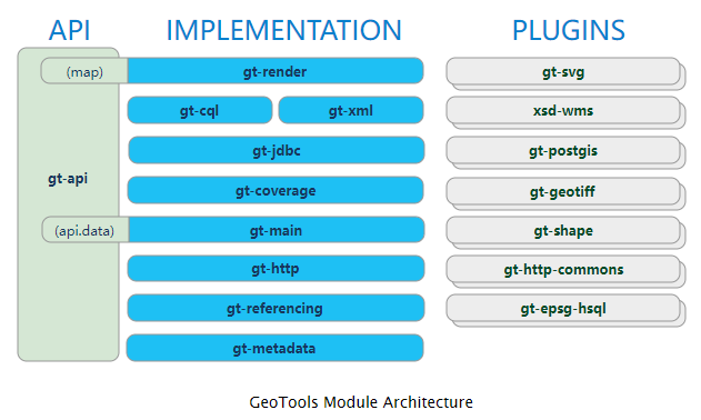
GeoTools库形成了一个软件“堆栈”,每个模块都建立在前一个定义的模块之上。
“堆栈”的每一层都是建立在下一层之上的,例如:
- 如果要使用
Referencing,你需要先使用gt-api,gt-metadata,gt-references,为了确保EPSGcodes的正确,还需要使用一个插件gt-epsg-hsql来定义EPSG。 - 如果要使用
Coverage,需要使用gt-api,gt-metadata,gt-referencing(包含gt-epsg-hsql),gt-main和gt-coverage。为了充分利用Coverage模块,我们使用了一个插件,比如gt-geotiff来访问GeoTIFF文件。
Maven工具能够计算项目中需要的jar.
下面是各个模块的作用:
| Module | Purpose |
|---|---|
gt-render |
Map API, with Java2D rendering engine for mapping. |
gt-jdbc |
Implements for accessing spatial database |
gt-xml |
Implements of common spatial XML formats |
gt-cql |
Implements of Common Query Language for filters |
gt-coverage |
Implementation for accessing raster information |
gt-main |
Data API, with default implementations of filter, feature, etc… |
gt-referencing |
Implementation of coordinate location and transformation |
gt-metadata |
Implementation of identification and description |
gt-api |
Definition of interfaces for common spatial concepts |
jts |
JTS Topology Suite (external library) implementing Geometry |
3. GeoTools 插件
GeoTools提供插件来支持额外的数据格式和不同的坐标参考系统等功能。
| Module | JAR | Plugin |
|---|---|---|
gt-render |
||
gt-jdbc |
gt-jdbc-db2 |
Geometry in DB2 |
gt-jdbc-h2 |
Pure Java “H2” database | |
gt-jdbc-mysql |
Geometry in MySQL | |
gt-jdbc-oracle |
Oracle SDO Geometry | |
gt-jdbc-postgis |
PostgreSQL extension PostGIS | |
gt-jdbc-sqlserver |
SQL Server | |
gt-jdbc-hana |
SAP HANA | |
gt-xml |
||
gt-cql |
||
gt-main |
gt-shape |
Shapefile read/write support |
gt-wfs |
WFS read/write support | |
gt-coverage |
gt-geotiff |
GeoTIFF raster format |
gt-arcgrid |
arcgrid format | |
gt-mif |
MIF format | |
gt-image |
JPG, PNG, TIFF formats | |
gt-referencing |
epsg-access . |
Official EPSG database in Access |
epsg-hsql |
Pure Java port of EPSG database | |
epsg-wkt |
Lightweight copy of EPSG codes | |
epsg-postgresql |
PostgreSQL port of EPSG database | |
gt-metadata |
||
gt-api |
||
jts |
通常,每个层至少需要一个插件才能让GeoTools做一些事情。
4.GeoTools 扩展
更进一步,在GeoTools库的基础上实现了一些有趣的“扩展”。这些扩展提供了使用核心库的全部功能构建在GeoTools之上的额外功能。
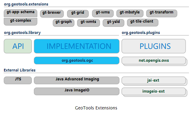
这些扩展相互独立,可能在您的应用程序中使用:
| JAR | Extension |
|---|---|
gt-app-schema |
Map from application schema to complex feature model |
gt-brewer |
Generation of styles using color brewer |
gt-complex |
Support for making custom complex feature model |
gt-graph |
Work with graph and network traversals |
gt-grid |
Dynamicly generate features from grid definiton |
gt-transform |
Transform features on the fly |
gt-wms |
Web Map Server client |
gt-wmts |
Web Map Tile Server client |
gt-xsd |
Parsing/Encoding for common OGC schemas |
5.XML
用途:解析和输出sld文件,wfs事务操作
为了支持GeoTools中的XML模块,我们以JAR形式捆绑了几个XML模式(以避免每次需要时都需要从Internet下载它们)。此外,这些jar包含一个由Eclipse Modeling Framework生成的Java数据结构。
| JAR | Schema |
|---|---|
net.opengis.ows |
open web services schema |
net.opengis.wfs |
web feature service |
net.opengis.wps |
web processing service schema |
net.opengis.wcs |
web coverage service schema |
net.opengis.wfs |
web feature service schema |
org.w3.xlink |
XLink schema |
XSD解析器通过一系列XSD插件使用这些工具。这些插件指示如何使用Eclipse XSD库解析和编码附加内容,以解析XML模式文档,并提供“绑定”,显示如何解析和编码Java类,如String、Date、URL和Geometry。
| JAR | Bindings |
|---|---|
gt-xsd-core |
Basic types defined by XML schema |
gt-xsd-fes |
filter 2.0 |
gt-xsd-filter |
filter (used by OGC CAT and WFS) |
gt-xsd-kml |
keyhole markup language |
gt-xsd-wfs |
web feature service |
gt-xsd-wps |
web processing service |
gt-xsd-gml3 |
geographic markup language 3 |
gt-xsd-gml2 |
geographic markup language 2 |
gt-xsd-ows |
open web services |
gt-xsd-wcs |
web coverage service |
gt-xsd-wms |
web map service |
gt-xsd-sld |
style layer descriptor |
6. 不支持的部分
还有一些“不支持”的插件和扩展。这些模块不是由项目管理委员会作为GeoTools下载的一部分分发的,但是它们可以通过maven或个人下载获得。
| Unsupported | Purpose |
|---|---|
gt-swt |
Standard widget toolkit interactive map |
gt-swing |
Swing interactive map |
gt-oracle |
retired oracle support |
gt-postgis |
retired PostGIS support,gt-jdbc-postgis |
gt-db2 |
retired db2 support |
gt-wps |
Web Processing Service client |
gt-process |
Job system for spatial data |
参考文章
[1] architecture https://docs.geotools.org/latest/userguide/welcome/architecture.html