11 KiB
| title | date | author | tags | categories | ||
|---|---|---|---|---|---|---|
| PostGIS 矢量瓦片 | 2020-09-11 | ac |
|
|
![]()
Martin - 基于PostGIS的矢量瓦片服务器
1. 简介
目前流行的矢量瓦片的切图方案:
mapbox gl+ tippecanoe :v2收费,tippecanoe是mapbox官方推荐的矢量瓦片静态生成工具 ,适用于大数据量场景,且不频繁更新的空间数据;openlayers+geoserver:开源,使用geoserver的矢量瓦片扩展,增加矢量瓦片的输出格式;maplibre+Martin+postgis :开源,martin是矢量切片服务器,通过postgis的函数动态生成矢量瓦片。maptiler:收费
mapbox v2 必须使用 access token 才能初始化 Map 对象。进行token计算,每月50000免费次数。
2. Martin
Martin是一个开源的PostGIS矢量切片服务器,可以从任何PostGIS表或视图中创建MVT矢量切片,也可以从 PMTile 和MBTile文件中动态生成矢量瓦片,是使用 Rust编写,针对切片速度和大流量进行了优化,是极快且轻量级的切片服务器。
2.1 安装
如果将Martin和PostgreSQL一起使用,PostGIS版本必须为v3.0+
Martin支持Linux、macOS、windows平台和docker环境,本例采用windows环境。先从github上下载martin-Windows-x86_64 。解压后会发现这两个exe:
─martin-Windows-x86_64
  ├─martin.exe
  └─mbtiles.exe
windows平台可以直接使用martin.exe来启动切片服务器,可以先在命令行查看一下参数:
D:\tools\vectorTileTool\martin-Windows-x86_64>martin.exe --help
Blazing fast and lightweight tile server with PostGIS, MBTiles, and PMTiles support

Usage: martin.exe [OPTIONS] [CONNECTION]...

Arguments:
  [CONNECTION]...  Connection strings, e.g. postgres://... or /path/to/files

Options:
  -c, --config <CONFIG>
          Path to config file. If set, no tile source-related parameters are allowed
      --save-config <SAVE_CONFIG>
          Save resulting config to a file or use "-" to print to stdout. By default, only print if sources are auto-detected
  -s, --sprite <SPRITE>
          Export a directory with SVG files as a sprite source. Can be specified multiple times
  -k, --keep-alive <KEEP_ALIVE>
          Connection keep alive timeout. [DEFAULT: 75]
  -l, --listen-addresses <LISTEN_ADDRESSES>
          The socket address to bind. [DEFAULT: 0.0.0.0:3000]
  -W, --workers <WORKERS>
          Number of web server workers
  -b, --disable-bounds
          Disable the automatic generation of bounds for spatial PG tables
      --ca-root-file <CA_ROOT_FILE>
          Loads trusted root certificates from a file. The file should contain a sequence of PEM-formatted CA certificates
  -d, --default-srid <DEFAULT_SRID>
          If a spatial PG table has SRID 0, then this default SRID will be used as a fallback
  -p, --pool-size <POOL_SIZE>
          Maximum connections pool size [DEFAULT: 20]
  -m, --max-feature-count <MAX_FEATURE_COUNT>
          Limit the number of features in a tile from a PG table source
  -h, --help
          Print help
  -V, --version
          Print version
2.2 使用
本例pg安装postgis是v3.3.3.1
martin连接pg可以用connection_string(命令行参数)和配置文件两种形式。
PostgreSQL连接字符串的形式:
# martin.exe postgresql://user:password@host/db
D:\tools\vectorTileTool\martin-Windows-x86_64>martin.exe postgresql://postgres:123@127.0.0.1:5433/postgres
[2023-08-08T03:50:11Z INFO  martin] Starting Martin v0.8.7
[2023-08-08T03:50:11Z INFO  martin] Config file is not specified, auto-detecting sources
[2023-08-08T03:50:11Z INFO  martin::pg::pool] Connecting to postgresql://postgres:123@127.0.0.1:5433/postgres
[2023-08-08T03:50:11Z INFO  martin::pg::configurator] Discovered source zhujiang_river from table public.zhujiang_river with geom column (MULTIPOLYGON, SRID=4326)
[2023-08-08T03:50:11Z INFO  martin] Use --save-config to save or print Martin configuration.
[2023-08-08T03:50:11Z INFO  martin] Martin has been started on 0.0.0.0:3000.
[2023-08-08T03:50:11Z INFO  martin] Use http://0.0.0.0:3000/catalog to get the list of available sources.
配置文件的形式 config.yaml:
# Connection keep alive timeout [default: 75]
keep_alive: 75

# The socket address to bind [default: 0.0.0.0:3000]
listen_addresses: '127.0.0.1:3000'

# Number of web server workers
worker_processes: 8
# Database configuration. This can also be a list of PG configs.
postgres:
  # Database connection string. You can use env vars too, for example:
  #   $DATABASE_URL
  #   ${DATABASE_URL:-postgresql://postgres@localhost/db}
  connection_string: 'postgresql://postgres@localhost:5433/postgres?sslmode=disable&user=postgres&password=123'

  # Same as PGSSLCERT for psql
  #ssl_cert: './postgresql.crt'
  # Same as PGSSLKEY for psql
  #ssl_key: './postgresql.key'
  # Same as PGSSLROOTCERT for psql
  #ssl_root_cert: './root.crt'

  #  If a spatial table has SRID 0, then this SRID will be used as a fallback
  default_srid: 4326

  # Maximum connections pool size [default: 20]
  pool_size: 20

  # Limit the number of table geo features included in a tile. Unlimited by default.
  max_feature_count: 1000

  # Control the automatic generation of bounds for spatial tables [default: false]
  # If enabled, it will spend some time on startup to compute geometry bounds.
  disable_bounds: false
D:\tools\vectorTileTool\martin-Windows-x86_64>martin.exe -c config.yaml
[2023-08-08T03:54:43Z INFO  martin] Starting Martin v0.8.7
[2023-08-08T03:54:43Z INFO  martin] Using config.yaml
[2023-08-08T03:54:43Z INFO  martin::pg::pool] Connecting to postgresql://postgres@localhost:5433/postgres?sslmode=disable&user=postgres&password=123
[2023-08-08T03:54:43Z INFO  martin::pg::configurator] Discovered source zhujiang_river from table public.zhujiang_river with geom column (MULTIPOLYGON, SRID=4326)
[2023-08-08T03:54:44Z INFO  martin] Use --save-config to save or print Martin configuration.
[2023-08-08T03:54:44Z INFO  martin] Martin has been started on 127.0.0.1:3000.
[2023-08-08T03:54:44Z INFO  martin] Use http://127.0.0.1:3000/catalog to get the list of available sources.
本例采用的是配置文件的形式启动服务器,服务地址是http://127.0.0.1:3000。
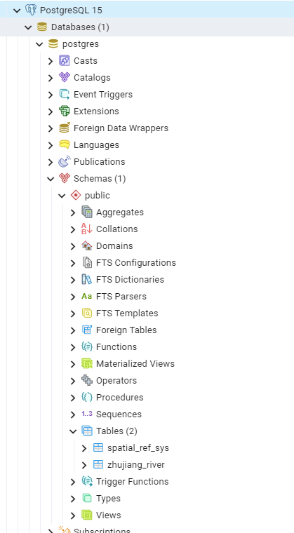
从启动的日志可以看到Martin将所连接的pg库中的zhujiang_river表发布为数据源。
Martin 会将所有表发布为数据源(如果它们至少有一个几何列)。如果 SRID 为 0,则必须设置默认 SRID,否则该地理列/表将被忽略。所有非几何表列都将发布为矢量切片要素标签(属性)。
打开目录可以看到已发布的数据源:
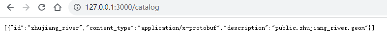
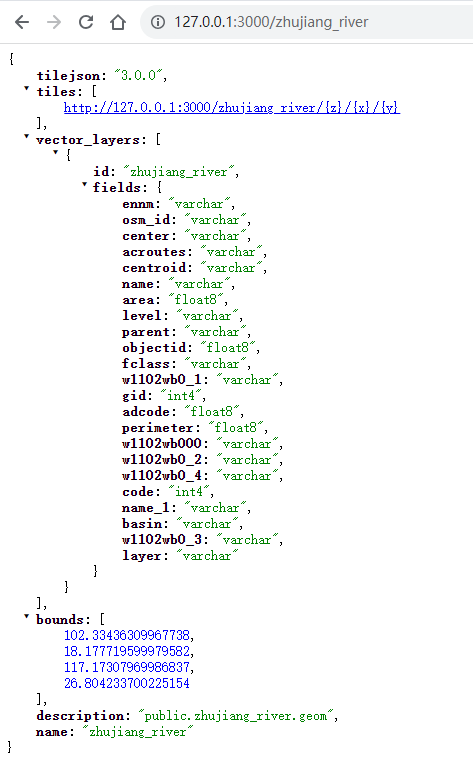
数据表的元数据是符合TileJSON 3.0.0标准的JSON文件。
Martin为每张要素表都提供一个TileJSON endpoint。
TileJSON是表示地图元数据的开放标准,endpoint这个词以前经常被用来描述进程间通信。
2.3 mapbox
发布完数据源后,使用mapbox gl 来调用一下:
<!DOCTYPE html>
<html lang="en">
<head>
    <meta charset="UTF-8">
    <meta http-equiv="X-UA-Compatible" content="IE=edge">
    <meta name="viewport" content="width=device-width, initial-scale=1.0">
    <title>Document</title>
    <script src="https://unpkg.com/mapbox-gl@1.9.1/dist/mapbox-gl.js"></script>
    <link href="https://unpkg.com/mapbox-gl@1.9.1/dist/mapbox-gl.css"/>
    <style>
        #map{
            height: 100vh;
            width: 100%;
        }
    </style>
</head>
<body>
    <div id="map"></div>
    <script>

        const TIANDITU_URL = 'http://t0.tianditu.gov.cn';
        const tdtKey = "your_token";
        const tdtConfig = {
            code: 'tdt_img',
            name: '天地图影像',
            source: {
                type: 'raster',
                tiles: [
                    `${TIANDITU_URL}/DataServer?T=img_w&x={x}&y={y}&l={z}&tk=${tdtKey}`
                ],
                tileSize: 256,
                minzoom: 0,
                maxzoom: 22
            },
            layer: {
                id: 'tdt-img-tiles',
                type: 'raster',
                minzoom: 0,
                maxzoom: 22,
                layout: { visibility: 'visible' }
            }
        }
        let map = new mapboxgl.Map({
            container:'map',
            style:{
                "version":8,
                "sources":{},
                "layers":[],
                glyphs: "mapbox://fonts/mapbox/{fontstack}/{range}.pbf",
            },
            center: [112.39747, 22.908823], // 广东
            zoom: 8, // starting zoom 地图初始的拉伸比例
            pitch: 0, // 地图的角度,不写默认是0,取值是0-85度,一般在3D中使用
            bearing: 0, // 地图的初始方向,值是北的逆时针度数,默认是0,即是正北
            antialias: true, // 抗锯齿,通过false关闭提升性能
            minZoom: 3,
            maxZoom: 17.36
        });
        map.on('load', () => {
            // 天地图底图加载
            addLayerConfig(tdtConfig);
            addMvt();
        });
        function addLayerConfig(layerConfig){
            const {code, source,layer} = layerConfig;
            map.addSource(code, source);
            const layerParams = {
                ...layer,
                source: code
            };
            // 添加图层
            map.addLayer(layerParams);
        }
        function addMvt(){
            map.addLayer({
                id: 'lines',
                type: 'fill',
                source: {
                    type: 'vector',
                    url: 'http://localhost:3000/zhujiang_river'
                },
                'source-layer': 'zhujiang_river',
                paint: {
                	'fill-color': 'red'
                }
            });
        }
    </script>
</body>
</html>
加载效果:

2.4 openlayers
由于postgis 切片生成的是mvt格式图片,所以只能使用web墨卡托坐标系
3.应用
3.1 docker安装
[root@localhost martin]# pwd
/home/martin
# 下载martin镜像
[root@localhost martin]# docker pull ghcr.io/maplibre/martin:main
main: Pulling from maplibre/martin
7264a8db6415: Pull complete
8b9d286dcf48: Pull complete
ada398a88aa0: Pull complete
Digest: sha256:13b38133bc15fd1d8b9b9444ca28e0380146799f1faa4c1f418090f067d48474
Status: Downloaded newer image for ghcr.io/maplibre/martin:main
ghcr.io/maplibre/martin:main
4. 遇到的问题
局限性:只能连接一个pg库。
对于有分库的系统,可以使用Nginx来转发。
4.1 表没有空间索引
Table public.table_name has no spatial index on column geom
CREATE INDEX table_name_geom_idx
ON table_name
USING GIST (geom);
参考文章
[1] Martin https://martin.maplibre.org/
[2] Martin Tile Server Documentation https://maplibre.org/martin/installation.html